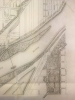
Map in 21st Annual Report of the Board of Park Commissioners of St Paul, MN, 1911. Available at the Minnesota Historical Society library as SB482.M62 S313 1904–1913.
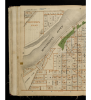
Map of the area around Cherokee Park, 1908. From Atlas of the City of St. Paul (H. M. Smyth Printing Company, 1908). Available at the Minnesota Historical Society library as OVERSIZE G1429.S4 C83 1908.
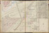
Image from Plat Book of the City of St. Paul, Minn and Suburbs (G. M. Hopkins Company, 1928). Available at the Minnesota Historical Society library as OVERSIZE G1429.S4 S2 1928.
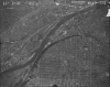
Aerial photograph of the Mississippi River southwest of downtown St. Paul, with Cherokee Park visible in the upper right, 1953. Minnesota Historical Aerial Photographs Online, John R. Borchert Map Library, University of Minnesota.
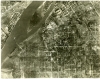
Aerial photograph of the Mississippi River southwest of downtown St. Paul, with Cherokee Park visible in the lower left, 1937. Minnesota Historical Aerial Photographs Online, John R. Borchert Map Library, University of Minnesota.
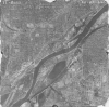
Aerial photograph of the Mississippi River southwest of downtown St. Paul, with Cherokee Park visible in the lower left, 1923. Minnesota Historical Aerial Photographs Online, John R. Borchert Map Library, University of Minnesota.