- Membership |
- Shop |
- Calendar |
- Donate
A resource for reliable information about significant people, places, events, and things in Minnesota history.
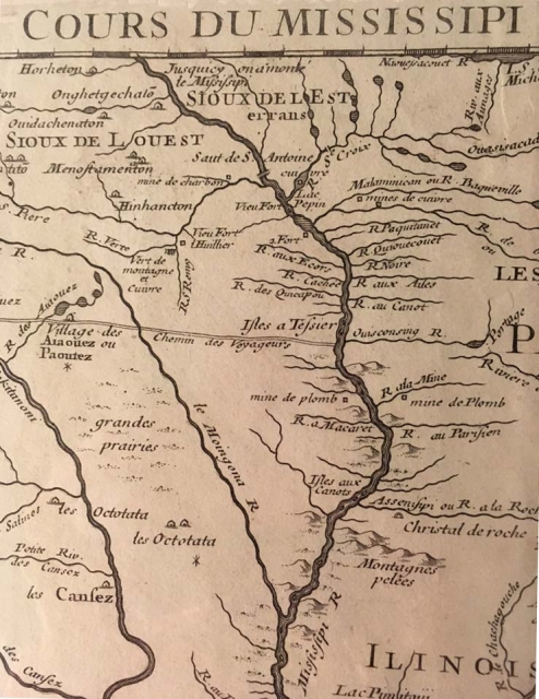
Detail of a map of land claimed by France for King Louis XV and the route of the Mississippi River (Carte de la Louisiane et du cours du Mississippi), 1718. Map by Guillaume de L'Isle, published by Chez l'Auteur. The map shows three French fur trading forts, labeled “Vieux forts,” just below the label “Saut de S. Antoine” (S.t Anthony Falls, Minneapolis). Two of them were likely trading posts built by Le Sueur (1695 and 1700). The third remains a mystery. Ten years later a fourth fort would be built at the site of Frontenac. The Root River is listed as “R. aux Ecors.” The Prairie du Chien area is at the mouth of the Wisconsin River, listed as “Ouisconsing R.” From this river to the west is the “Chemin des Voyageurs”—the Voyageurs’ Trail—ending at a large “Aiaouez” (Ioway; Bahkhoje) village whose residents traded buffalo products and pipestone with Europeans. From the maps collection of the MInnesota Historical Society, St. Paul (G3700 1718 .L5 Reserve 4F).
Made possible by the Arts and Cultural Heritage Fund through the vote of Minnesotans on November 4, 2008. Administered by the Minnesota Historical Society.
Minnesota Historical Society • 345 W. Kellogg Blvd., St. Paul, MN 55102-1906 (Map) • 651-259-3000 © MNHS.
Send questions or comments to mnopedia![]() mnhs [dot] org. View our Privacy Policy.
mnhs [dot] org. View our Privacy Policy.