- Membership |
- Shop |
- Calendar |
- Donate
A resource for reliable information about significant people, places, events, and things in Minnesota history.
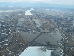
Aerial photograph showing flooding in the Traverse Gap, the former southern outlet of Glacial Lake Agassiz and the source of River Warren. Ice-covered Lake Traverse (Mde Hdakiŋyaŋ), a natural border between Minnesota (left) and South Dakota (right) is at bottom center; Big Stone Lake (Mde Iŋyaŋ Taŋka) is at top center. Photo by JOR Engineering, Inc., March 14, 2007. CC BY-SA 3.0
About 13,000 years ago the melting glaciers that covered Minnesota and Canada created a vast lake, bigger than all the Great Lakes of today combined. Geologists later named this Lake Agassiz (AH-ga-see), for the Swiss geologist Louis Agassiz. The lake drained twice: first to the south, to form the channel of the Minnesota River and the Upper Mississippi in the Twin Cities, and then, 1,600 years later, to form the course of the Red River of the North.
Between 17,000 and 21,000 years ago the last North American glacier reached its maximum depth and extent, covering all but the southeast corner of Minnesota. Its slow melting and retreat then began. Some 13,000 years ago its meltwater formed Glacial Lake Agassiz, which covered most of what is now Saskatchewan and Alberta, plus a sliver of northwest Minnesota and eastern North Dakota. Its waters were contained by the ice sheet to the north and a natural dam to the south, since named the Big Stone Moraine. (A moraine is a ridge of debris formed by a glacier.)
About 11,700 years ago the lake breached the moraine near present-day Browns Valley, Minnesota, at a place now called Traverse Gap. The flow of water and debris surged south, then southeast, with unimaginable force, creating what geologists later named the Glacial River Warren. This river carved a wide, deep valley—now the Minnesota River valley—which turned north at Mankato, because it hit bedrock, joined the much smaller Mississippi River at Fort Snelling, and joined the St. Croix at Hastings. It thus formed the river network around which all human habitation in southern Minnesota has since been organized.
When River Warren’s surge reached what is now downtown St. Paul, about 10,000 years ago, it flowed atop the shelf of limestone upon which the city now stands. When it reached the edge of that shelf it met much softer rock—shale, with sandstone beneath. It then proceeded to cut deeply into that material, forming the basin still visible south of downtown. In time the flow dug a deep chasm, and the water cascading over the limestone edge formed a waterfall 175 feet tall and 2,700 feet across (later named River Warren Falls) spanning the entire basin from downtown to Cherokee Heights.
The force of falling water ate away at the sandstone under the limestone shelf, and little by little the edges of the shelf broke off, again and again and again. Thus the falls marched slowly upstream to the west, progressively diminishing in height and force, until they reached the Mississippi at the site of Fort Snelling. It then followed the Mississippi north, split off at Minnehaha Creek to form Minnehaha Falls (where the shelf and softer rock below can still be seen), and continued north to what became Minneapolis. Dakota people called the water feature Owamniyomni: Turbulent Waters. After 1680, when Father Louis Hennepin saw the site and named it for the patron saint of Padua, Italy, it became known to Euro-Americans as St. Anthony Falls.
While Glacial River Warren worked its way east, then north, the glacier, far to the north in Canada, continued to melt. Lake Agassiz re-formed, though smaller. About 7,400 years ago it broke through the weakening ice to the north and east, and flowed toward Hudson’s Bay, creating the shallow valley of the Red River of the North, which extends from Lake Traverse to the south to Winnipeg, and beyond, in a shallow, gently sloping valley. The breakthrough eventually drained all the accumulated melt water, and this marked the end of Lake Agassiz. In time the valley of the Red River proved to be fertile farmland, thus attracting European immigration and forming the population centers of western Minnesota and eastern North and South Dakota. The two successive drainings of Lake Agassiz created two of modern Minnesota’s three great river corridors: the Minnesota and the Red, along with the Mississippi.
Anfinson, John O. “Spiritual Power to Industrial Might: 12,000 Years at St. Anthony Falls.” Minnesota History 58, nos. 5 & 6 (Spring–Summer 2003): 252–269.
https://storage.googleapis.com/mnhs-org-support/mn_history_articles/58/v58i05-06p252-269.pdf
Anfinson, Scott F. “Archeology of the Central Minneapolis Waterfront.” Minnesota Archaeologist 48, nos. 1–2 (1989).
https://www.fromsitetostory.org/sources/papers/mnarch48/48hist.asp
——— . Southwestern Minnesota Archaeology: 12,000 Years in the Prairie Lake Region. Minnesota Historical Society, 1997.
Bluemle, John P. “Glacial Lake Agassiz.” North Dakota Geological Survey.
https://www.dmr.nd.gov/ndgs/ndnotes/agassiz
Gibbon, Guy. Archaeology of Minnesota: The Prehistory of the Upper Mississippi River Region. University of Minnesota Press, 2012.
Teller, J. T. “Proglacial Lakes and the Southern Margin of the Laurentide Ice Sheet.” In North America and Adjacent Oceans During the Last Glaciation, edited by W. F. Ruddiman and H. E. Wright Jr. Geological Society of America, 1987.
Teller, J. T., and L. Clayton, eds. Glacial Lake Agassiz. Geological Association of Canada Special Paper 26. Department of Geology, Memorial University of Newfoundland, St. John’s, 1983.
Upham, Warren. The Glacial Lake Agassiz. Monographs of the United States Geological Survey, vol. XXV. Government Printing Office, 1895.
https://pubs.usgs.gov/publication/m25
Wright, H. E., Jr. Geologic History of Minnesota Rivers. St. Paul: Minnesota Geological Society, 1990.
https://www.swwdmn.org/wp-content/uploads/2016/03/Geologic-History-of-MN-Rivers.pdf
 |
 |
 |
 |
 |
 |
About 11,700 years ago Lake Agassiz breaks through the natural dam at its south end, at present-day Traverse Gap. The water surge carves out what we now call the Minnesota River Valley.
The Laurentide ice sheet covers all but the southeast corner of Minnesota. This is its maximum extension; it then begins slowly to melt and recede.
The melting ice sheet has created a vast lake covering present-day Alberta, Saskatchewan, northern Minnesota, and the eastern Dakotas, which later became known as Lake Agassiz.
Lake Agassiz cuts through its southern barrier, the Big Stone Moraine, carving a channel up to one mile wide and 150 feet deep. The watercourse created later named Glacial River Warren. The Minnesota River now flows through the remains of this channel.
River Warren Falls takes shape at what is now downtown St. Paul.
River Warren Falls reaches what is today the confluence of the Minnesota and Mississippi Rivers and splits in two. The Minnesota River falls eventually disappears. The falls in the Mississippi channel becomes known much later as St. Anthony Falls.
A break in the ice in the far north allows what remains of Lake Agassiz to flow north. The Red River of the North now flows through this channel. And this event marks the end of Glacial River Warren, which carried water flowing south and east.
The water feature Dakota people come to call Owamniyomni (Turbulent Waters, later also called St. Anthony Falls) reaches roughly its current location.
The Army Corps of Engineers completes a concrete wall under the shelf of St. Anthony Falls, thus stopping its erosion and preserving it in place at downtown Minneapolis.
Made possible by the Arts and Cultural Heritage Fund through the vote of Minnesotans on November 4, 2008. Administered by the Minnesota Historical Society.
Minnesota Historical Society • 345 W. Kellogg Blvd., St. Paul, MN 55102-1906 (Map) • 651-259-3000 © MNHS.
Send questions or comments to mnopedia![]() mnhs [dot] org. View our Privacy Policy.
mnhs [dot] org. View our Privacy Policy.